|
Last Visited: October, 2003
History:
The original Edgartown Lighthouse was built in 1828, on a small man-made island in the Edgartown harbor. An Act of Congress allocated money to build it 1/4 mile from shore. Later, $5,500 was appropriated to complete the project and Seth Vincent was paid $80 for a right of way to the tower. For the first year, the only way to get to the light was by boat, but another $2,500 was allocated to build a foot bridge.
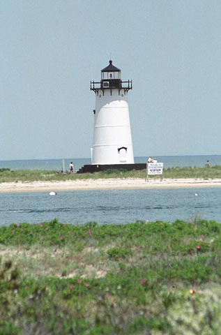
The first structure was replaced in 1938 by one that was rafted to the Vineyard from Ipswich. Although the new light was placed on the original site, sand had filled in the area between the island and the mainland, and the current Edgartown Lighthouse stands on shore.
The Island sits in treacherous seas, with one tide coming in from Boston, affecting the south side of the Vineyard, and another from Rhode Island, affecting the north shore. There are reefs, rocks, and shoals, and the infamous Devil's Bridge off Aquinnah, which wrecked the steamship The City of Columbus on January 18, 1884, with the loss of 120 crew and passengers in the icy waters.
================
Perhaps nowhere is the notion of romance more firmly embedded than at the Edgartown Light. First put up in 1828, the light was originally built into the roof of a twelve-room keeper's dwelling on a man-made island a quarter of a mile offshore at the entrance to the Edgartown Harbor. A long wooden pier connected the lighthouse to the shore. The wooden walkway became known as the Bridge of Sighs because it was where the young men of Edgartown took their girlfriends before they went off on a long whaling voyage.
In 1937 the keeper's house with its cupola-style light was in poor shape, and the government announced plans to replace it with a-gasp-steel tower. This proposal for "navigational improvements" in the outer Edgartown Harbor inflamed the lighthouse passions in Edgartown and there was a storm of protest from townspeople.
Finally a compromise was struck and the Essex Light at Ipswich was dismantled and shipped to Edgartown on a barge. This is the tower which stands today.
Source:
Martha's Vineyard Online
Source:
Vineyard Gazette Online

Latitude/Longitude: 41.390847,-70.503024
Nearest Address: 127 N Water St, Edgartown, MA
Directions:
- From ferry landing in Vineyard Haven take a right onto Beach Rd, then bear left onto Main St.
- 0.3 miles later turn left onto RR2.
- Take RR2 3.5 miles and bear left onto RR1.
- Stay on RR1 for 3.4 miles, then bear right (it's actually the same road) onto Main St in Edgartown.
- Take Main St. for 1 mile into the center of Edgartown. Turn left onto N. Water St.
- Take N. Water St. to the end then turn right onto Starbuck Neck Rd.
- This will take you to the lighthouse.
View Larger Map
|


